


An Ancient Glacial Lake in the Okanagan
What proof do we have of an extraordinary mega-flood in the Okanagan?

In a UBC Report by Bud Mortenson published in April 2007 he explained a theory by Robert Young an Assoc. Prof. of Geography and Earth and Environmental Sciences at UBC Okanagan that indicates that a great body of water formed over the Okanagan Valley as a result of melting ice sheets.
Young’s theory goes even farther, with new evidence suggesting an Ice-Age megaflood that created Washington State’s Channeled Scablands about 15,000 years ago partly originated in south-central British Columbia, not exclusively from Montana as the prevailing theory suggests.
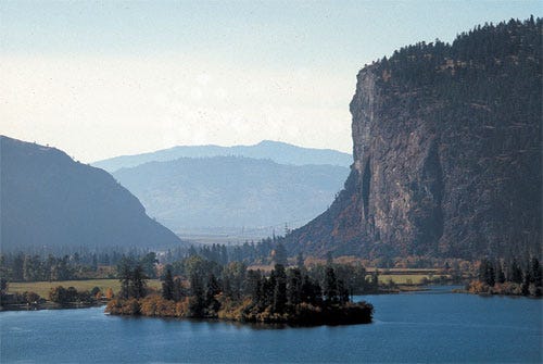
McIntyre Bluff in the South Okanagan. Was it the site of a huge ice dam that eventually broke?
The megaflood’s statistics are staggering. Arriving from the northeast, a wall of water tall enough to leave gravel bars 120 metres high ripped across Washington at 120 kilometres per hour, eroding more than 80 cubic kilometers of earth and rock in two or three days. The torrent left a scoured 25,000-square-km landscape riddled with deep canyons -- known as coulees -- carved out of the hard bedrock.
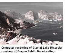
“The question of where all that water came from has been hotly debated for decades,” says Young. Most think the floodwater came from Glacial Lake Missoula, 400 kilometres away in Montana. As big as Lake Ontario and Lake Erie combined, Lake Missoula was held back only by a dam of ice near the Montana-Idaho border. The long-held hypothesis is that when the ice dam broke, the water poured westward with unimaginable fury and destruction.
Lake Missoula breaching its ice dam may have been impressive, Young says, but probably not impressive enough to account for the Scablands. “Models of dynamic hydrology suggest that floodwaters from the Missoula Basin alone were insufficient to fill the Scabland coulees, much less do all of the work required to produce the incredible landscapes in the region.”
Instead, Young is looking for a water source from the north, where the massive Cordilleran ice sheet covered much of British Columbia. His attention is on a lobe that buried B.C.’s Okanagan region beneath nearly three kilometres of ice, terminating almost on top of the Scablands south of the Okanagan.
A cataclysmic chain of events originating under this southern B.C. ice, perhaps triggered by volcanic eruptions from below and surface meltwater making its way through the immense ice sheet, would change prevailing theories about one of the greatest flash floods of the last Ice Age.
“The Okanagan and surrounding uplands are part of dramatic landscapes, including landforms carved into bedrock like the Channeled Scablands,” Young says. “Features such as water-eroded channels that can go uphill, and streamlined landforms caused by fluids flowing turbulently at high velocities, all suggest huge flows came out of the Okanagan Valley and drained south into the Columbia drainage.”
He argues that massive volumes of melt water flowing under the Okanagan ice pushed southward -- probably along more than one path. Part exited from the southernmost point of the ice sheet, purging into the Scablands.
More water rushed southeast down the southern Rocky Mountain Trench into Glacial Lake Missoula, and under glaciers emanating from the Purcell range. When the ice dam at Glacial Lake Missoula failed, floodwaters spilled west several hundred kilometres into the Scablands hours or days after the initial onslaught.
Young says the challenge is that, until only recently, sub-glacial reservoirs have not been considered candidates for the kind of catastrophic flooding that created the Scablands.
However, there’s evidence today that huge volumes of water do collect under ice sheets and are released in outbursts of flooding. “Movement of large water volumes of melt water beneath the Antarctic ice sheets have been reported by several researchers in the last few years,” Young points out.
“And in Greenland gigatons of water on top of ice sheets have been observed draining through the ice very quickly -- in as little as 48 hours.”
Over several years, he says, water accumulates under the ice and eventually it can lift or “decouple” the ice and flood through any exit it finds. “In Iceland, this process occurs regularly, and is greatly accelerated when intermittent sub-glacial volcanic eruptions occur, causing the reservoir to overfill, and leading to flows many times those normally seen during regular outburst floods,” Young says.
There’s evidence of volcanic eruptions beneath the ice sheet just north of the Okanagan -- in what today is B.C.’s Wells Gray Provincial Park. “Many of the deposits and volcanoes there bear telltale marks of sub-glacial eruption, including pillow basalts on mountainsides and flat-topped volcanoes,” Young says.
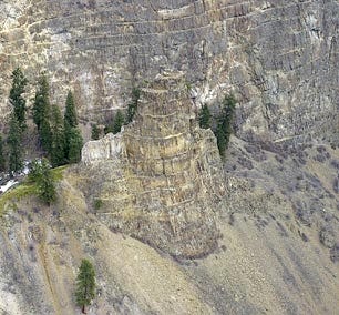
Hoodoos like the one pictured here at Layer Cake Mountain in Kelowna can also be found at Denison Lake south of Creighton Valley near Lumby - good examples of ancient water erosion.
“Volcanologists studying the region indicate that three volcanoes erupted sub-glacially during the last glaciation.” Volcanic activity and normal surface melting could eventually produce enough water to decouple the overlying ice and drain catastrophically, says Young.
“With no other sufficient source of water for the Scablands megaflooding, and equipped with several realistic mechanisms for water formation,” he says, “we must consider the Okanagan scenario as a valid alternative to Lake Missoula alone accounting for such a catastrophic event.”
So the question remains, was the great sea a submerged one covered by a thick layer of ice, or had the ice melted forming a much warmer environment in this ancient region?
Had this ancient Okanagan Lake called Glacial Lake Penticton actually triggered the Great Missoula Flood?
Was McIntyre Bluff near Okanagan Falls the site of a giant ice dam?
Could a meteorite crashing into the vicinity have triggered these events and if so where did it make contact?
Perhaps the historical data has yet to be discovered to give us clear answers. But ancient seashells and coral along the edge of a tiny lake between Lumby and Cherryville may provide further clues about this ancient landscape, its great inland sea, as well as its first inhabitants.
To learn more about us visit: www.wildcraftforest.com
Rocks: Mysterious Geological Features and Getting Fossilized
Rock hoodoos hidden in the forest define an age when the Earth was torrent with lava and volcanic vents. Because the area is remote and largely unknown, much of the secrets of this geological landscape have yet to be revealed.
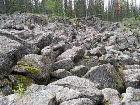
Denison-Bonneau Provincial Park offers some easy access to mysterious geological features and can be reached by turning south from Creighton Valley Road near Lumby. The park offers an abundance of post-volcanic and glacial history; however, these exceptional features found in this park are not well studied or documented.
The area is probably an erosional remnant of an extensive volcanic complex that developed after a huge chasm split open the Earth’s crust along the ancestral Okanagan Valley, possibly 60 million years ago, in early Tertiary times. The site then witnessed the last significant geologic event here, which involved erosion by thick glaciers and ice sheets that periodically ground their way across the land during the Ice Age that began about two million years ago.
The Okanagan and most of British Columbia may have been glaciated at least six times. The latest glacial event is known as the Fraser Glacier that advanced 20 to 25 thousand years ago, and began to melt about 15,000 years ago. As the glacial melt occurred some of the landscape became submerged under water while high points in the Okanagan Highlands where Denison-Bonneau Park is found, served as islands which may have eventually formed an archipelago and eventually a land bridge that meandered between two great inland seas.
Learn more about Denison-Bonneau Provincial Park: https://bcparks.ca/denison-bonneau-park/
To learn more about us visit: www.wildcraftforest.com
Getting Fossilized
The Royal BC Museum has within it a fossil collection, of approximately 55,000 specimens, ranging from delicate impressions from the Paleozoic Burgess shale (nearly 600 million years old) to mammoth and mastodon bones and teeth from the past 20,000 years.
The museum has beautifully preserved remains of fish that once swam in the Triassic seas where the Rockies now stand. Ammonite fossils represent many swimming cephalopod mollusks that lived 70 to 90 million years ago in Late Cretaceous seas on what is now the east side of Vancouver Island.
The Haida Gwaii (formerly known as the Queen Charlotte Islands) is represented by many invertebrate species. The collection also contains turtles and bones and footprints of dinosaurs that roamed northern BC at the end of the Cretaceous; 50 million-year-old plant and insect fossils from the Kamloops area; and mollusks and vertebrate remains from 25 million years ago found at Sooke on Vancouver Island. Bird bones from Hornby Island; bison bones from Victoria and samples of lake, bog and stratigraphic sections from the last ice ages (Pleistocene Epoch) are also preserved.
The museums earliest fossils were collected in the 1870s by George M. Dawson an early explorer of the Monashee. Recent additions include a fossil bird and fish from the interior of BC; a Cretaceous fossil plant collection; and a mammoth tusk collected from the Cowichan River.
Learn more about the The Royal BC Museum Natural History Collection: https://www.royalbcmuseum.bc.ca/collections/natural-history/palaeontology
The Wildcraft Forest Channel on Roku offers a great opportunity to experience deep nature every day. Whether it’s from our own original programming or from great programs provided by others, we ensure unique and inspirational content.
Programs like Trends; The Nature Report; Elementals and Entropy provide a chance for Deep Nature Meditation; Ancient Wisdom and Skills; Forest Mysteries as well as News and Issues related to ecology and the cosmos.
Learn about Sanctuary Forests which are not only spiritual temples supported by nature, but they are providing new values, qualities and systems that are strengthening the desire for protecting standing forests as living organisms within a 300 year stewardship plan. At the Wildcraft Forest we understand that everything is connected.
Learn more, visit: www.wildcraftforestchannel.com